


Satellite image shows China's extensive planning!!!
After the infiltration of 300 Chinese soldiers in Arunachal Pradesh on december 9, the big intention of the dragon has come to the fore. indian soldiers bravely chased away the Chinese soldiers who had entered the Yangtse area of the tawang Sector, but now the satellite images that have surfaced have raised the ears of the indian Army.
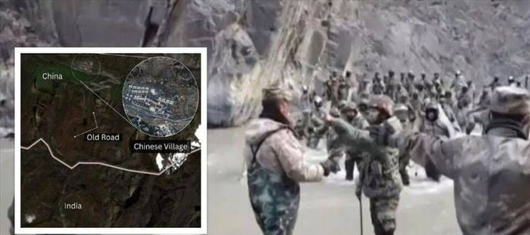
According to the indian Army, china has built large-scale infrastructure in its area close to the Line of Actual Control. From Arunachal Pradesh to the Chinese-occupied area of the Doklam region, which was the cause of the first standoff between the two countries, china has built new bridges, built villages and also built roads, which are in this area. Giving indications of some planned intention. However, after the december 9 incident, in a statement from the Chinese Foreign Ministry, talks have been said to stabilize the situation on the LAC and maintain normalcy between the two countries.
Chinese infrastructure in Doklam is a matter of greater concern
The Doklam area is located in sikkim at the trijunction where the India-Tibet-Bhutan borders meet. In this area called the siliguri Corridor, the indian territory gets reduced to just 22 kilometres wide. At this place, there was a 73-day standoff between the armies of india and china in the year 2017 and the fighting was narrowly avoided. That deadlock was about building a road in the Bhutanese area of china close to the indian border.
Now in the latest satellite images, evidence has been found of large-scale infrastructure preparation in this area of china in its occupied part. china has prepared concrete strong tunnels close to the border, in which heavy ammunition can be stored. Along with this, the number of its soldiers has also doubled. Along with this, china has also prepared a bridge, which will prove helpful in taking its soldiers to the indian border fast.
 click and follow Indiaherald WhatsApp channel