


Mandya district is an administrative district of Karnataka. Mandya District borders on the south by Mysore district, on the west by Haasan district, on the north by Tumkur district and on the east by Ramanagar district. The district was formed in the year 1939.
_at_Kikkeri,_Mandya_district.JPG)
1. Mandya district gets its name from the city of Mandya which is also the headquarters of the district. Although the widely purported mythical story about the name is that the region is named after a sage called Maandavya, but scholars and academicians have stated based on ancient inscription that this region was referred as 'Man-ta-ya', meaning a habitat preceding a civilization or roughly an ancient abode.
2. The importance of the district's headquarters town, Mandya, grew with the establishment, in January 1933, of the Mandya Sugar Factory with an authorized capital of Rs. 20 Lakhs a great amount those days. Predictably the sugar factory is now one of the biggest in India.
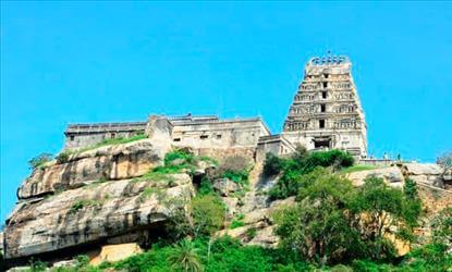
3. Mandya town also contains the stately Janardhanaswami temple whose principal deity holding the traditional Shanka and Chakra i5 flanked by Sridevi and Bhudevi on either side. The temple's gopura recently renovated adds to the aesthetics of the temple.
4. The district covers an area of about 4850.8 square kilometers, about 1/40th of the area of the whole state. The area is plain except for a few outcrops of rocks that stand out as ridges and an extension of the Biligirirangana range of mountains in the southeast. Perhaps among Mandya's greatest assets are its four rivers, the Cauvery, Hemavati, lokapavani and Shimsha that give the district both religious importance and scenic beauty.
 click and follow Indiaherald WhatsApp channel