


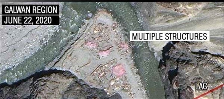

Reportedly day after india and china agreed to start the process of disengagement along the Line of Actual Control (LAC) in Ladakh, high-resolution satellite images showed the presence of Chinese structures on both sides of the LAC in the Galwan river valley. Earlier satellite images of May 22 showed the presence of a single tent at this spot. The new satellite images show multiple shelters and other structures sprouting up along the rock-face leading up the LAC. These structures were not spotted in the earlier satellite images, clearly indicating that china has no intention to de-escalate the massive buildup to reduce tensions at the border.
''There are clear signs of an incursion around Patrol Point 14. These appear to be defensive formations by the Chinese on our side of the Line of Actual Control,'' says Major General Ramesh Padhi (retd.), one of India's foremost cartographers who retired as Additional Surveyor General of India. "The images show a clear movement of heavy vehicles which indicates that they have an intention to stay deployed in the area."
However, india has completed a major highway approximately six kilometers away, which connects Durbuk in the south with Daulat Beg Oldie in the North. It is believed that the construction of this road, which enables indian forces to restore their positions in the region, was a matter of concern for Chinese forces. While the talks were held in a cordial manner, both sides are yet to begin the process of physically moving their forces back to build mutual confidence.
 click and follow Indiaherald WhatsApp channel